One of the most famous travel destinations in Hokkaido, the northernmost island of Japan, is Niseko town with its world class ski resorts and lots and lots and lots of powder snow. The scenery in this area is dominated by Mt. Yotei (1,898 m / 6,227 ft). Besides Niseko, there are four other towns and a village at the foot of the majestic Mt. Yotei; towns of Kutchan, Kyogoku, and Kimobetsu as well as Makkari village. The towns and villages are located in southeastern Shiribeshi area, about one and half hour drive southwest from Sapporo, the main hub of Hokkaido.
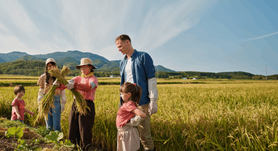
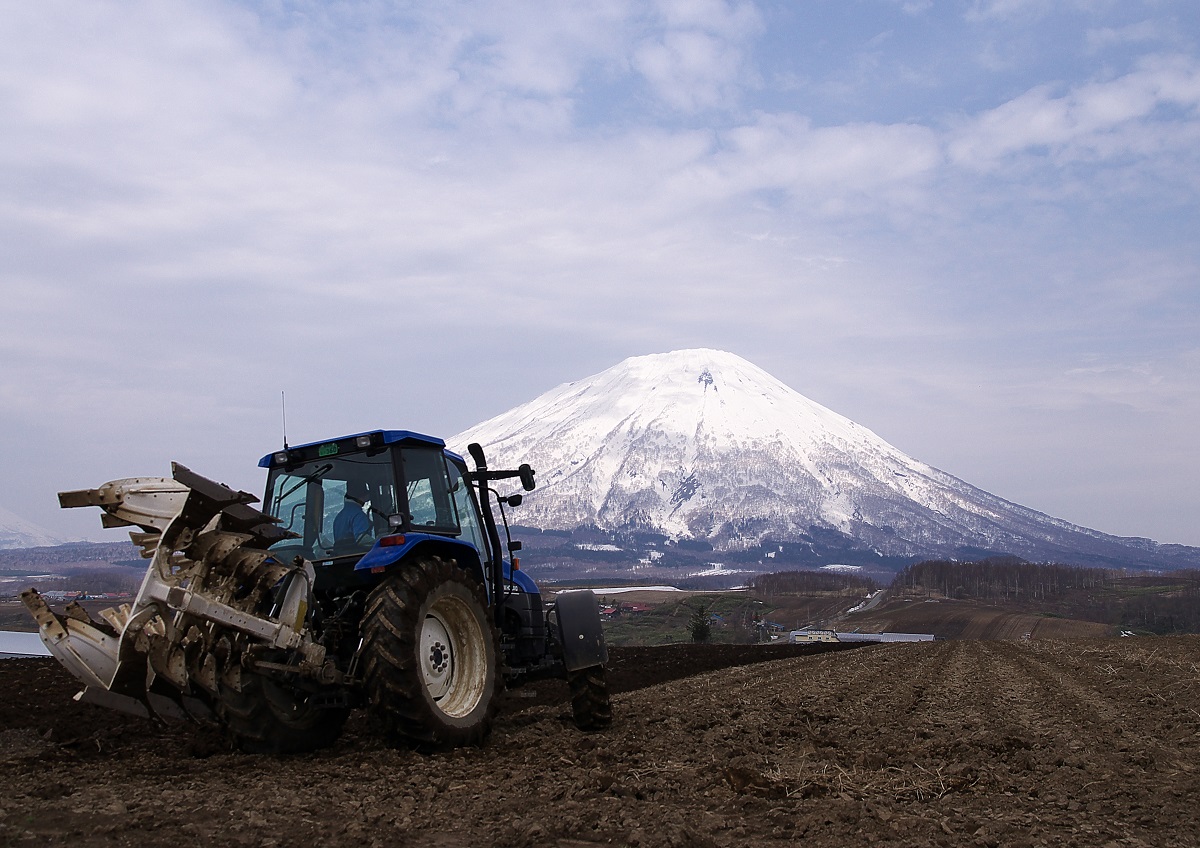
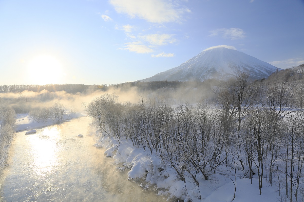
The area is famous for its ski resorts and of course for Mt. Yotei. Mt. Yotei is an active stratovolcano that resembles world-famous Mt. Fuji—hence the nickname Mt. Fuji of Hokkaido. Mt. Yotei is well-loved among the mountain climbers and there are four trails to the mountain with their trailheads in different towns around the mountain. In the winter, Mt. Yotei and the nearby Niseko mountain range are popular among skiers. Since Mt. Yotei is a volcano, the soil in the surrounding area is fertile with volcanic ash and the main industry in the area is agriculture.
This blog column, you can read about Mt. Yotei, the towns and villages surrounding the mountain and the activities to participate there.
If you want to read more especially about what to do during your travels in Niseko, take a look at our earlier blog column Niseko: the town of fantastic powder snow.
Introducing the towns around Mt. Yotei and Niseko
The towns around Mt. Yotei and neighboring Niseko are all quite small with agriculture as their main industry, so they are not probably your typical travel destination and that’s why they are more than suitable for off the beaten path travellers! All the towns in Japan tend to have some local specialty products, and the towns surrounding Mt. Yotei are not an exception. They also happen to have one speciality in common. Read on to get to know what!
Kutchan town
Kutchan town sits at the northern foot of Mt. Yotei. It is the capital of the Shiribeshi subprefecture with an area of 261.24 square kilometers. In 2021, there were 14,842 inhabitants in the town. There are several excellent places for skiing at the Niseko mountain range to the west of the town and Kutchan is indeed known for its winter sports—especially for skiing— but also for being the town of softball. Being a town living on agriculture, the main crops of Kutchan are potatoes, which are celebrated yearly in the Potato festival in early August.
The origin of the name Kutchan is in Ainu language—the language of indigenous Ainu people of Japan and Russia—and the same goes for about 80% of all the Hokkaido place names. There are several explanations for the meaning of the name Kutchan. In Ainu, the name is ‘kut san i’ and it is interpreted to mean ‘the thing that flows down by the cliff’ (that is, the river flowing by the cliff), or ‘the river flowing in a tube like place’—however, there is not this kind of geographical formation in the area—or a type of fishing equipment of shape of a tubular basket. The river mentioned here is Shiribetsu river (and its tributary Kutosan river), which flows through Kimobetsu, Kyogoku, and Kutchan towns all the way to the west and the Sea of Japan.
Kyogoku town lies in east of Mt. Yotei. The town has an area of 231.49 square kilometers and there were 2,886 inhabitants as of August 2021. Like Kutchan, Kyogoku is a famous potato producer and is especially known for its Irish cobbler variety. There is also a saké brewery, which produces saké made of pure clear water from Mt. Yotei. Name of the town is only one of the four towns and villages introduced here without roots in Ainu language. The original name of the town was Higashikutchan (“Eastern Kutchan”) but it was renamed as Kyogoku in 1940. The new name comes from the surname of Japanese nobleman Takanori Kyogoku, who started agriculture in the area in the late 19th century.
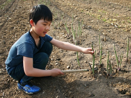
When you proceed to the south from Kyogoku, you will reach Kimobetsu; a small agriculture town with an area of 189.51 square kilometers and in 2021 about 2,000 inhabitants. The main produce of the town is asparagus and, you guessed it right, potatoes. National highways 230 and 276 cross at Kimobetsu and if you drive the route 276 towards Mt. Yotei and Kyogoku town, you can indulge yourself in one of the best views of Mt. Yotei rising higher and higher to the sky while getting closer to the mountain. The name Kimobetsu also has its origins in the Ainu language. It comes either from ‘kim un pet’, that is ‘the river that enters the mountains’, or from ‘kim o pet’, ‘the river that is in the mountains’. The river in question is the Kimobetsu river, which enters the mountains to the east of Kimobetsu. There are old records of people following the course of the river to find the path to cross the mountains between Kimobetsu and Sapporo.
Makkari village
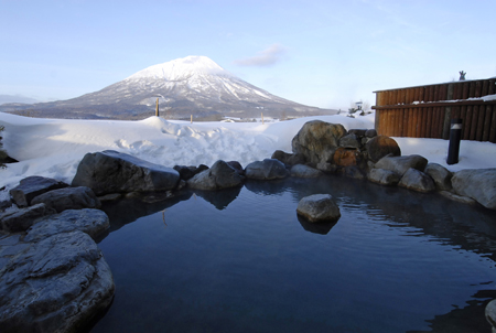
Last but not the least, there is Makkari village, a cozy rural village to the south of Mt. Yotei. The village had 1,998 inhabitants in August 2021 within its compact size of 114.43 square kilometers. Believe it or not but Makkari is also known for its potatoes. Besides potatoes, it produces another, a bit more rare sort of starchy tubers, namely lily bulbs. Makkari offers one of the trailheads to Mt. Yotei, so it’s a good place to start if you wish to hike the mountain. After the hike, Makkari onsen hot spring spa offers relief to your sore muscles and a spectacular view to Mt. Yotei from the rotenburo outdoor bath. In Ainu, the original name of the village is said to be either ‘mak kari p’ (the thing that turns deep into the mountains) or ‘mak kari pet’ (the river that turns deep into the mountains), which means the village got its name from the River Makkari flowing through it. The upper reaches of the river are really winding, hence the name.
The magnificent Mt. Yotei
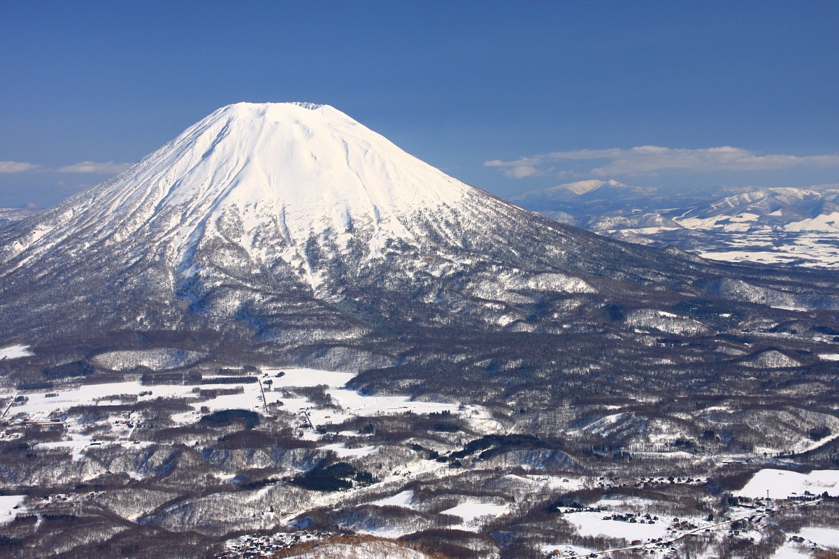
With its last eruption somewhere between 50000 and 6000 years ago, Mt. Yotei is an active stratovolcano (an outbound link). The dramatic mountain rises up to the height of 1,898 m (6,227 ft) and dominates the view in the towns and villages around it. The mountain has almost perfect conical shape that resembles world-famous Mt. Fuji—hence the nickname Ezo-Fujisan, that is ‘Mt. Fuji of Ezo’ or ‘Mt. Fuji of Hokkaido’ in English (Ezo is the old name of Hokkaido).
Actually, the mountain has had several other names and the Japanese name Mt. Yotei (Yoteizan in Japanese) was established only quite recently. The old name of the mountain was written as 後方羊蹄 in Japanese kanji characters, and the reading of the characters was ‘Shiribeshi’. As a note for those who are not familiar with the Japanese writing system, most of the kanji characters have several possible readings, some of them common and some of them rare. Shiribeshi is very rare reading for the characters 後方羊蹄 and people had difficulties to read the name correctly. A more common way to read the characters is Kohoyotei and the mountain was also called with that name, or in short, just Yotei (羊蹄). In 1969 the town of Kutchan turned in a suggestion to change the official name to Yoteizan (羊蹄山) (the last part ‘山’ or ‘zan’ meaning a mountain in Japanese) and the suggestion was approved.
The old name of Mt. Yotei—Shiribeshi—goes way back in time. There is a mention of the name in a Japanese historical record called Nihon Shoki (Chronicles of Japan) from the year 659! The records say that the emperor dispatched a man called Abe no Hirafu to go to Shiribeshi and to conquer the local inhabitants titled ‘emishi’, a name which probably refers to Ainu people. If you read carefully the explanation above about the origins of the name of Kutchan town, there is a mention of Shiribetsu river, and close to Mt. Yotei also is a smaller mountain called Mt. Shiribetsu (Shiribetsudake in Japanese). The name Shiribetsu derives again from the Ainu language and the original Ainu name of the river was either ‘si ri pet’ (‘a very high river’) or ‘sir pet’ (‘a mountain river’). These Ainu names are of course connected with the name Shiribeshi mentioned in the Chronicles of Japan.
However, Ainu themselves called Mt. Yotei (or Mt. Shiribeshi if you insist) ‘makkari nupuri’ or ‘macine siri’. You can read the explanation for the meaning of ‘makkari’ above, in the section with the explanation of the origins of the name of Makkari village. ‘Nupuri’ means ‘mountain’ in Ainu language. The other name, ‘macine siri’, means ‘a female mountain’, and if there is a woman, there must be a man, too. ‘The male mountain’, that is ‘pinne siri’ for Ainu, was the somewhat smaller Mt. Shiribetsu close to Mt. Yotei. There are also other mountain “husband and wife” pairs with the names ‘female mountain’ (‘macine siri’) and ‘male mountain’ (‘pinne siri’) in Hokkaido.
All the different names given to Mt. Yotei by the Japanese and the Ainu can be confusing, but the most important thing to know is that there are several ways you can enjoy the unbelievable gorgeous nature of the mountain. Since the mountain is an isolated mountain, it is easy to observe the change of vegetation when climbing higher up. The first 650 meters, there is a broadleaf forest which turns into needle-leaf trees and then around 1,000 meters height the vegetation changes again, this time to Erman’s birch zone. The alpine zone starts at about 1,600 meters. The mountain is also home to several animals, such as brown bears, Ezo red foxes and Siberian flying squirrels (Ezo momonga in Japanese).
In the summer, visitors can enjoy mountain climbing choosing from four different trails. The mountain trails are quite steep, so it is not the best of choice for total beginners. In the winter, you can enjoy backcountry skiing (off-piste skiing) at the mountain. The local guides can give you advice for the best routes depending on your wishes, physical fit, and skiing experience.
If you want to get more travel inspiration about hiking and mountain climbing in Hokkaido, why don’t you also take a look at our earlier blog columns Akan-Mashu National Park: Hot springs and caldera lakes and Daisetsuzan national park: The playground of the Gods?
Enjoying in nature around Mt. Yotei
The small towns around Mt. Yotei might not be the first destination in mind when planning a trip to Hokkaido but there are interesting things to see here, too. Here you can read about some of the attractions and activities available in the towns.
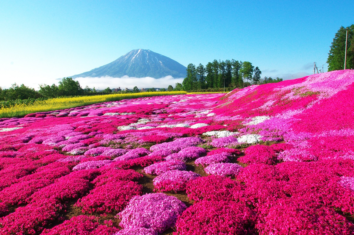
Japan is world-famous for its cherry blossoms but in Kutchan the visitors can enjoy another kind of flower viewing experience: pink moss phlox, in Japanese ‘Shibazakura’, that is ‘lawn cherry blossoms’. The lovely sight of a carpet of flowers in all shades of pink from almost white to fuchsia combined with Mt. Yotei in the background is really something you can’t see everyday. A local retired potato farmer Mr. Mishima started this spectacular garden as a hobby and it has become a must-see destination during a Hokkaido trip. The flowers are in season for about four weeks, starting around mid-May. So, if you are planning your Hokkaido trip during May or June, be sure not to miss this unique flower viewing experience.
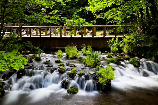
Being around mountains in Hokkaido usually means that there is plenty of fresh mountain water available at the foot of the mountain. Mt. Yotei is no exception to this. In Kyogoku, there is a famous water park, Fukidashi park (an outbound link), where you can calm down with the soothing effect of flowing water and admire the pleasing scenery of the water park. The spring, where the water originates from, gets its water from the melting snow of Mt. Yotei and spouts out overwhelming 80,000 liters of water every day! The Ainu call this spring water ‘Kamuy wakka’ or ‘water of the Gods’ and it indeed tastes very good, so don’t forget to take your water bottle with you when your trip takes you to Fukidashi park. After relaxing at the park, you can try out Kyogoku’s famous soba noodles, which are made with the local tasty water.
Being around mountains in Hokkaido usually means that there is plenty of fresh mountain water available at the foot of the mountain. Mt. Yotei is no exception to this. In Kyogoku, there is a famous water park, Fukidashi park (an outbound link), where you can calm down with the soothing effect of flowing water and admire the pleasing scenery of the water park. The spring, where the water originates from, gets its water from the melting snow of Mt. Yotei and spouts out overwhelming 80,000 liters of water every day! The Ainu call this spring water ‘Kamuy wakka’ or ‘water of the Gods’ and it indeed tastes very good, so don’t forget to take your water bottle with you when your trip takes you to Fukidashi park. After relaxing at the park, you can try out Kyogoku’s famous soba noodles, which are made with the local tasty water.
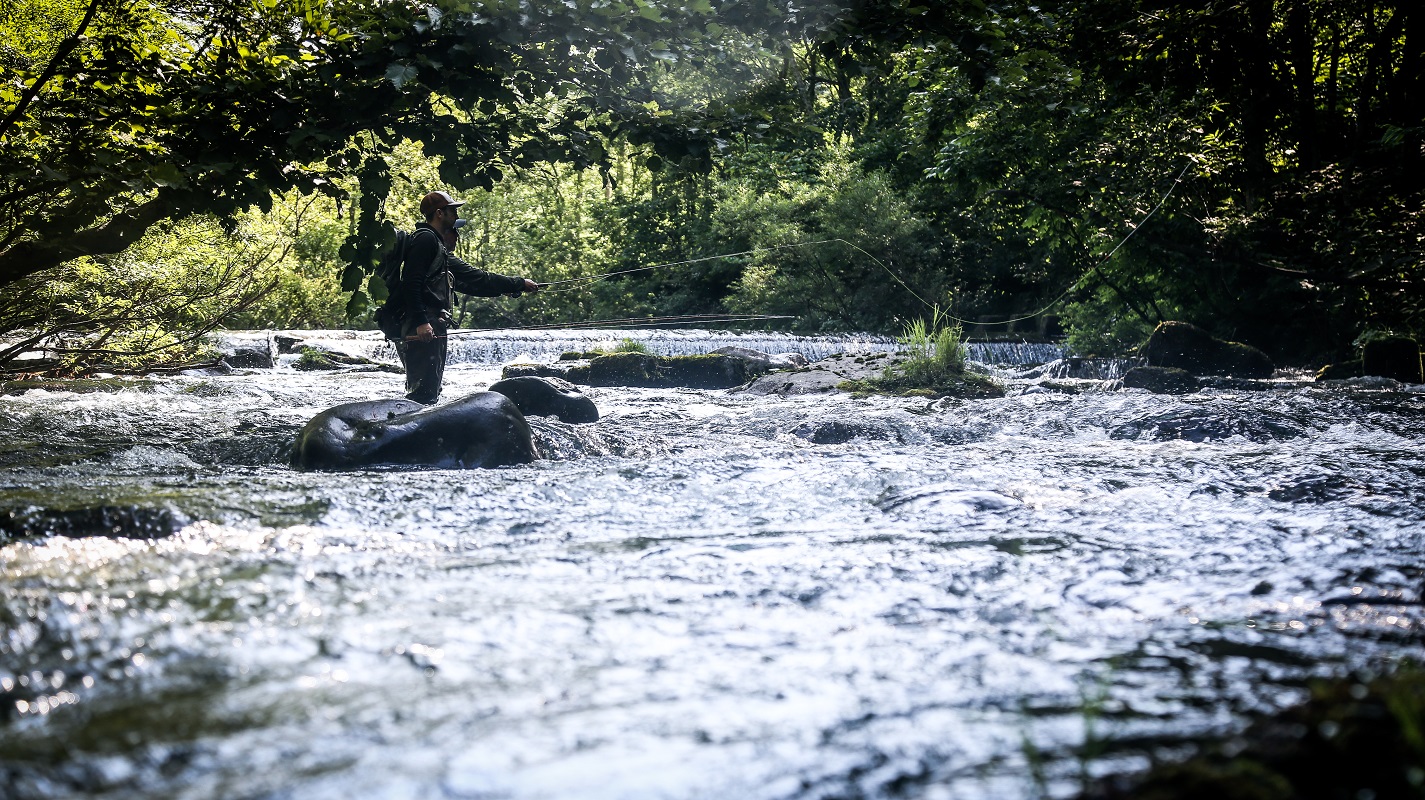
Another exciting activity to try around Mt. Yotei is fishing at the river Makkari in Makkari village. The snowmelt from the mountains adds to the water volume in the river during the spring and summer and makes the river to an extremely clear rapid flow. You can catch here Dolly Varden trout, Rainbow trout, and Landlocked salmon, among others. The fishing season in Hokkaido starts in June, so if you want to cast a line in Makkari river, you should plan your trip starting earliest in June.
Mt. Yotei from Niseko
Niseko Hirafu—a ski area that comprises 4 ski resorts at Mt. Niseko Annupuri—offers an excellent view of Mt. Yotei. Mt. Niseko Annupuri stands northwest from Mt. Yotei and it offers a direct view to Mt. Yotei over the Shiribetsu riven and the plain between them. The ski area has been developed since the 1960s and it spreads out from the foot of the mountain up to 1,200 meters (3,937 feet).
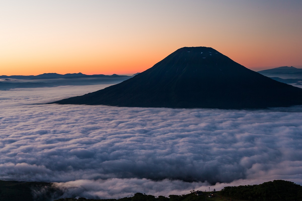
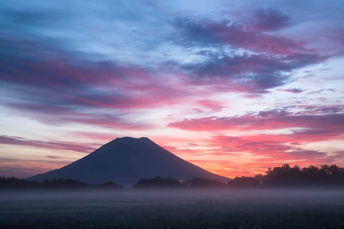
For the most uninterrupted view to Mt. Yotei, you can take a gondola ride up to the mountainside at Niseko Hirafu. While the main purpose of the gondola is to be a ski lift, it also operates during the summer and takes the visitors up to Mt. Niseko Annupuri to enjoy the spectacular view over Niseko town and Mt. Yotei. The spot is especially popular in the evenings when you can admire Red Fuji, that is the scenery of the setting sun coloring Mt. Yotei beautifully red.
So, what do you think, how about adding a tour in the towns around Mt. Yotei to your private tour itinerary? It’s less than a two-hour-long ride from Sapporo, so you can do a quick day trip or stay longer. Let us know which one suits you better when you contact us.