Table of Contents:
1. Introduction Rishiri and Rebun Islands, and the North Soya Area
2. Rebun Island – Floating Island of Flowers – Visit just for flowers that bloom only here
3. Rishiri Island – A mountain towering over the sea
4. North Soya – The northernmost city of Hokkaido and its magnificent view of the Soya Hills
5. Conclusion
Introduction
Hokkaido is the northernmost island of Japan. The islands of Rishiri and Rebun and the North Soya area are located in the far north of Hokkaido. Do you think those areas are just cold and lonely places? Well, they are not. In the north of Hokkaido, magnificent nature and beautiful scenery that cannot be found anywhere else await you. It would be a wasted opportunity not to go there because it is too far away. Let’s enjoy unknown northern Hokkaido to the fullest.
In the short summer, colorful flowers bloom in profusion. Rebun Island, in particular, is called the “floating island of flowers” and is a favorite destination for flower lovers from all over Japan, as it has many rare species that can only be seen here.
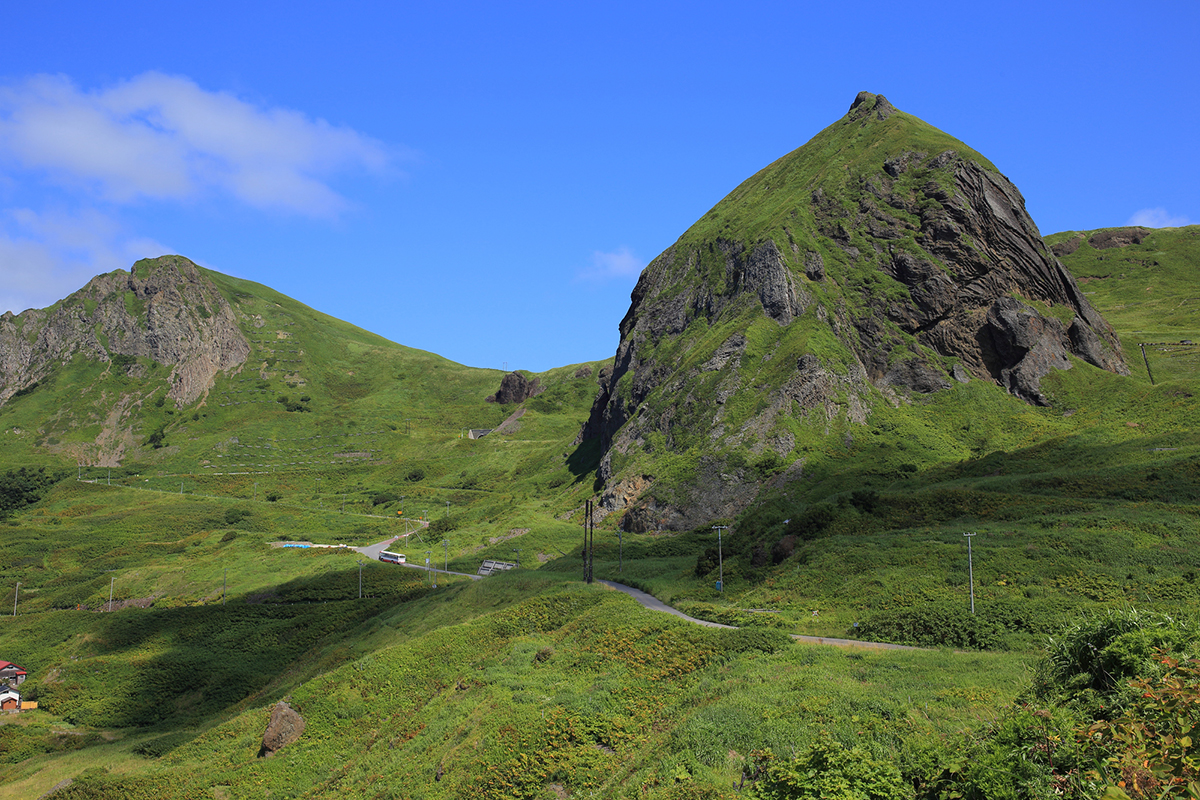
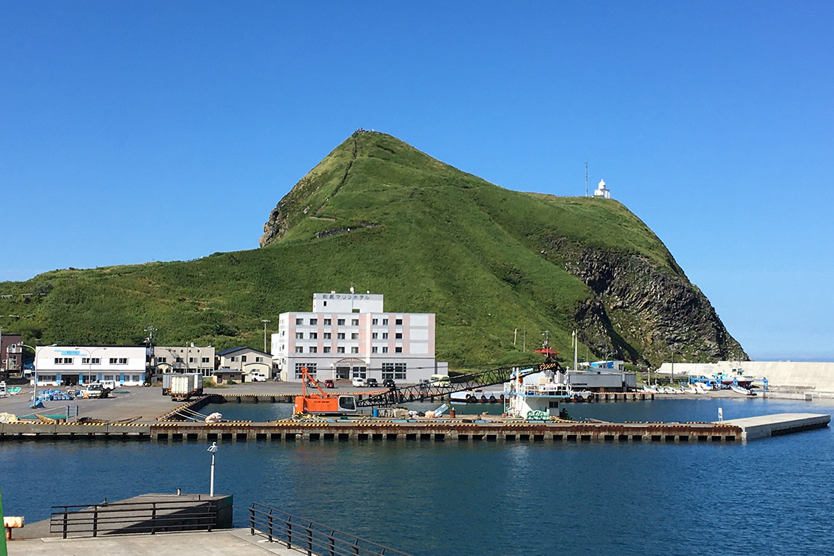
The entire shape of Rishiri Island is like a single mountain, and its beautiful conical shape is clearly visible from Wakkanai and neighboring waters, making it a landmark for navigation. It is also called “Rishiri Fuji”, which means Mt. Fuji on Rishiri Island. Mt. Rishiri has its name at the top of the list of ” One Hundred Mountains of Japan,” the bible of Japanese mountain lovers published in the 1960’s, since which time many people visit Rishiri Island just to climb this mountain.
North Soya refers to four municipalities in northern Hokkaido, including Wakkanai. Wakkanai, the northernmost city, has memories of prosperity about 100 years ago as the gateway to Sakhalin. You can see Sakhalin on a sunny day, just 43 km away from Cape Soya.
Many parts of these areas have been designated as The Rishiri-Rebun-Sarobetsu National Park, the northernmost national park in Japan. Enjoy the rich nature that can only be found here, and which endures the harsh northern climate.
Rebun Island, the Floating Flower Island – Visit just for flowers that bloom only here
Rebun Island is the northernmost island in Japan, and derives its name from the Ainu words “Repun Sir,” meaning “offshore island.” It takes about two hours by ferry from Wakkanai, the nearest town on the mainland of Hokkaido. Many tourists visit the island from June to August, when flowers that can only be seen here, such as the Rebun lady’s slipper orchids or Rebun edelweiss, are in bloom.
Trekking is recommended as a leisurely way to fully enjoy the island’s natural beauty. Rebun is a small island with a narrow shape that stretches about 29 km north to south and just 8 km east to west. The island doesn’t have any bears or snakes, so hikers can enjoy trekking in peace.
There are several official routes. The recommended course is the Momoiwa (Peach Rock) Observatory Course, which offers a unique view of a massive rock that looks like a huge peach, and you’ll see clusters of alpine flowers in bloom around there from June to August. From a lighthouse located on the west coast, you can see Mt. Rishiri seemingly floating on the sea. This route covers about 7 km from the Kafuka Ferry Terminal to the southern tip of the island, called Shiretoko, and it will take about 2 to 3 hours.
Another one is the Course Going around the Capes of Rebun which provides majestic views from the northernmost cape, and a beautiful bay surrounded by cliffs. On the way to visit the capes, you’ll see various kinds of adorable alpine flowers. It covers 12 km and will take about 4 to 5 hours.
The Eight-hour Course is the hardest route on the island. This course covers about 16 km from north to south along the west coast, which doesn’t have paved roads. The route changes drastically as you walk through grass fields and forests, and along the coast below the sea cliffs. Some areas don’t have an internet connection. There are no mountains on the course, but it’s not as easy as you might have expected. Some hikers might take more than eight hours. You need to prepare well in advance. So you can choose your favorite course according to your interests and physical strength.
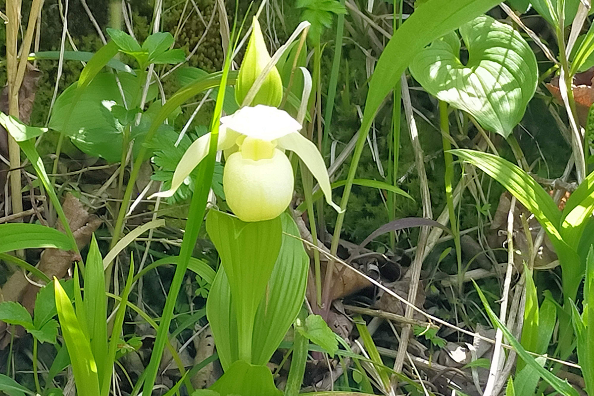
Rebun Island boasts one of the rarest species of orchid; the Rebun lady’s slipper orchid, (Rebun Atsumori-so, Cypripedium macranthos var. rebunense) found only on the island, has lovely cream-colored balloon-shaped petals and its flowers measure about 5 cm in diameter. It is a natural monument of Hokkaido and has been designated as an endangered species. Due to its rarity, flower lovers from many places in Japan flock to the island from late May to early June just to see it in bloom.
The plant used to be found all over the island, but numbers have been drastically reduced due to pilferage. This plant requires strict conditions for pollination, and even after germination, it takes 6 to 7 years to bloom, so once the number of flowers has decreased, it is difficult to increase their number again. Currently, the colony is protected by fences and patrols by local people.
There is the Alpine Garden on the north of the island, where visitors can see artificially cultivated Rebun lady’s slipper orchids. It was first grown successfully in 2001, and numbers have been increasing ever since. If you cannot visit the island during the blooming season, you can still see them at the garden until August.
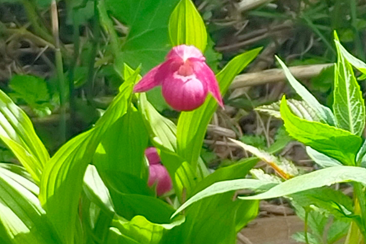
The red-colored lady’s slipper orchid is found in Honshu, the Japanese mainland, and is also a rare species. It also blooms on Rebun Island.
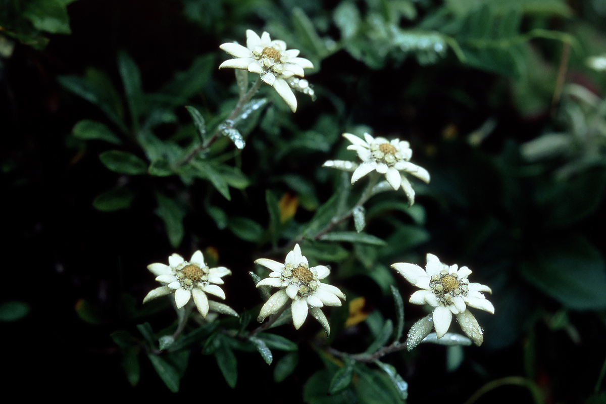
Another endemic species of Rebun Island is Rebun edelweiss (Rebun Usuyuki-so, Leontopodium Japonicum). It is from the same group of edelweiss as that of the European Alps. Its Japanese name Usuyuki-so comes from its petals which are densely covered with white hairs, making them look like a thin layer of snow (“usuyuki” in Japanese). It blooms from late June to mid-July in various parts of the island.
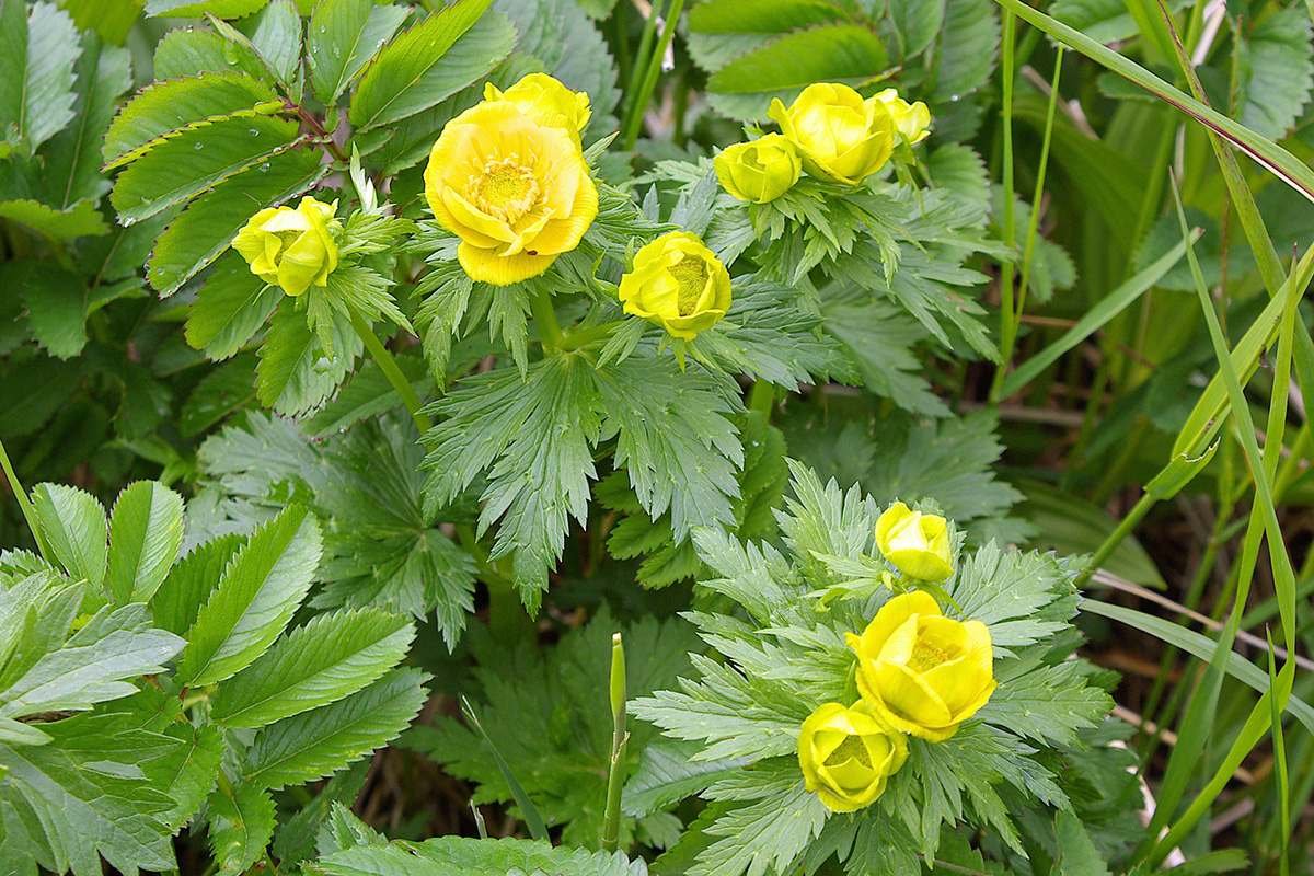
Rebun trollius (Rebun Kinbai-so, Trollius Ledebourii) is another species endemic to Rebun Island. There is a colony of these flowers in the south of the island. They bloom around June.
One of the attractions of this island is that you do not have to hike high mountains for alpine flowers. Normally in Japan, alpine flora can be seen after the forest limit of 2,000 meters above sea level, but since Rebun Island is located at a high latitude with a harsh climate, alpine flora can be found from zero meters above sea level. In other words, alpine flowers can be seen casually near residential areas without climbing high mountains. Let’s try to find alpine plants unique to this island.
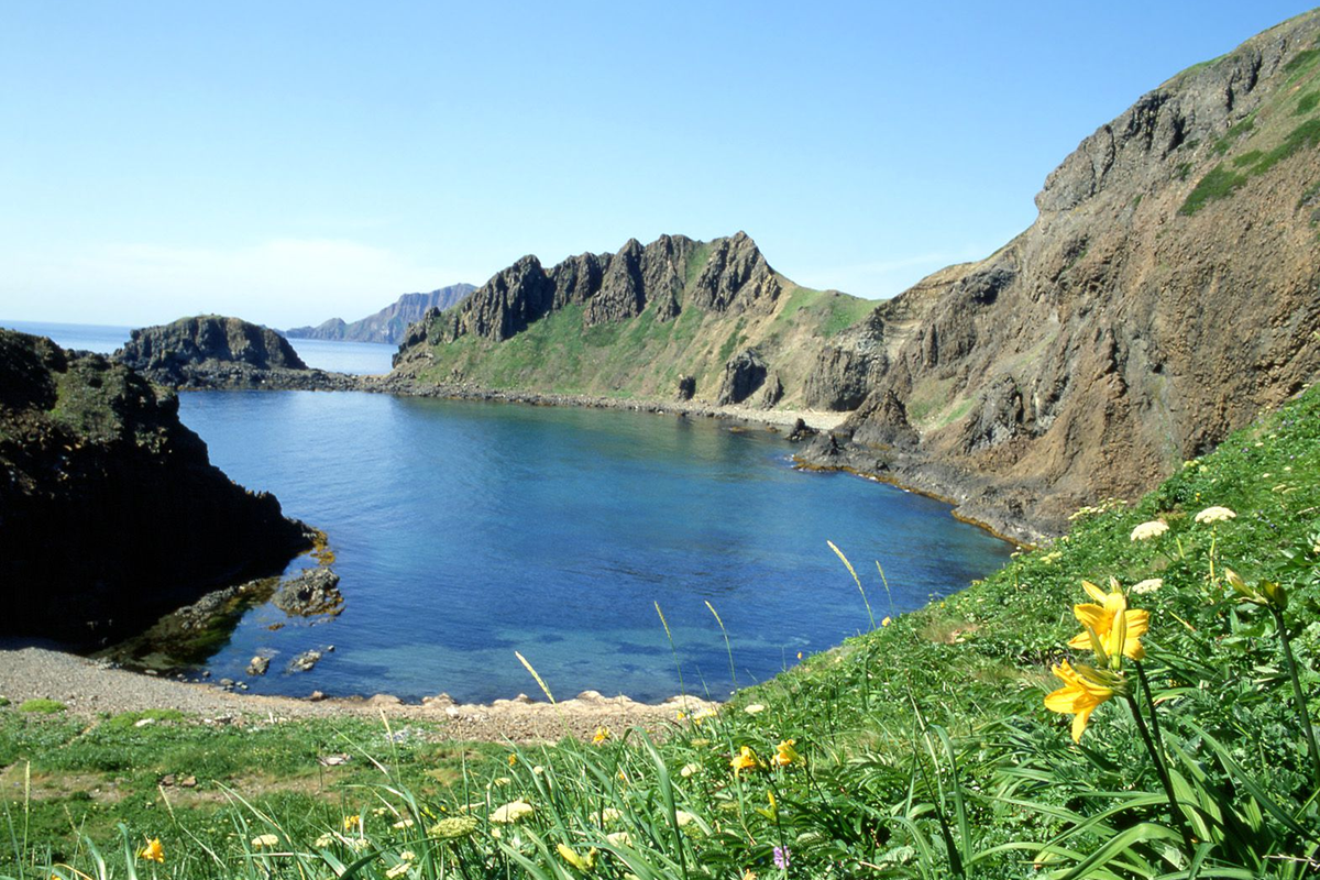
Rebun Island is also known for the beautiful views from its capes and the uniquely shaped rocks dotted throughout the island. Cape Sukai is located in the northwestern part of the island and is one of its most beautiful sightseeing spots with its blue sea surrounded by cliffs.
Cape Sukoton, the northernmost part of the island, is one of the popular tourist spots on this island. Strong winds always blow in this area. Hold on to your hat! Uninhabited Todo Island can be seen from the observatory. It is said that sea lions (“todo”) were hunted on this island hundreds of years ago. Nowadays seals can sometimes be seen near the island from the cape. On a clear day, the island of Sakhalin can be seen faintly in the distance.
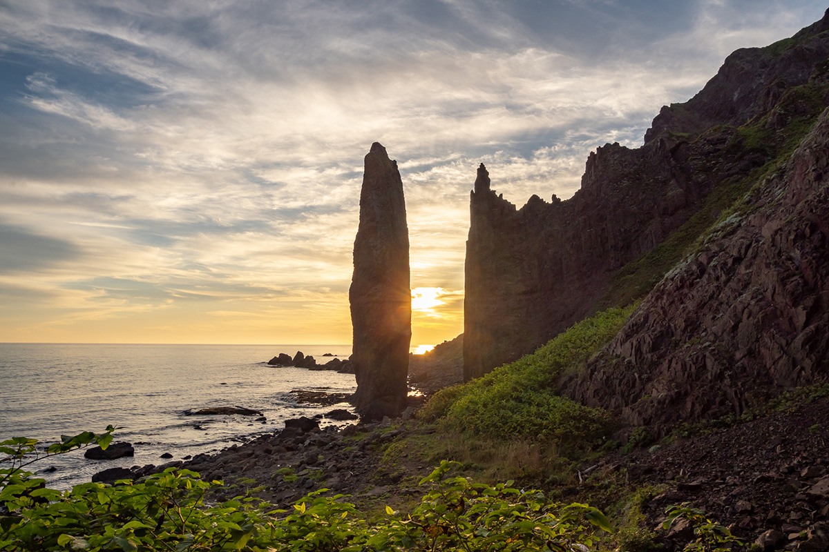
There are many uniquely shaped rocks on the island, including Momoiwa (Peach Rock) on the trekking course. The west coast is a rugged landscape of craggy rocks due to rough waves caused by the strong wind always blowing from the west. Nekoiwa (Cat Rock), which looks like a cat facing the sea, is one of those craggy rocks. There is also a huge, long and narrow rock called Jizo-iwa. Jizo is the name of one of Buddhism’s guardian deities who protects the souls of children from falling into hell. Jizo stone statues of this Buddhist deity are often found by the roadsides in Japan. Some say the rock’s name of Jizo comes from its shape like a Jizo guardian, and others say the rock’s shape resembles the hands of a Jizo putting its palms together in prayer.
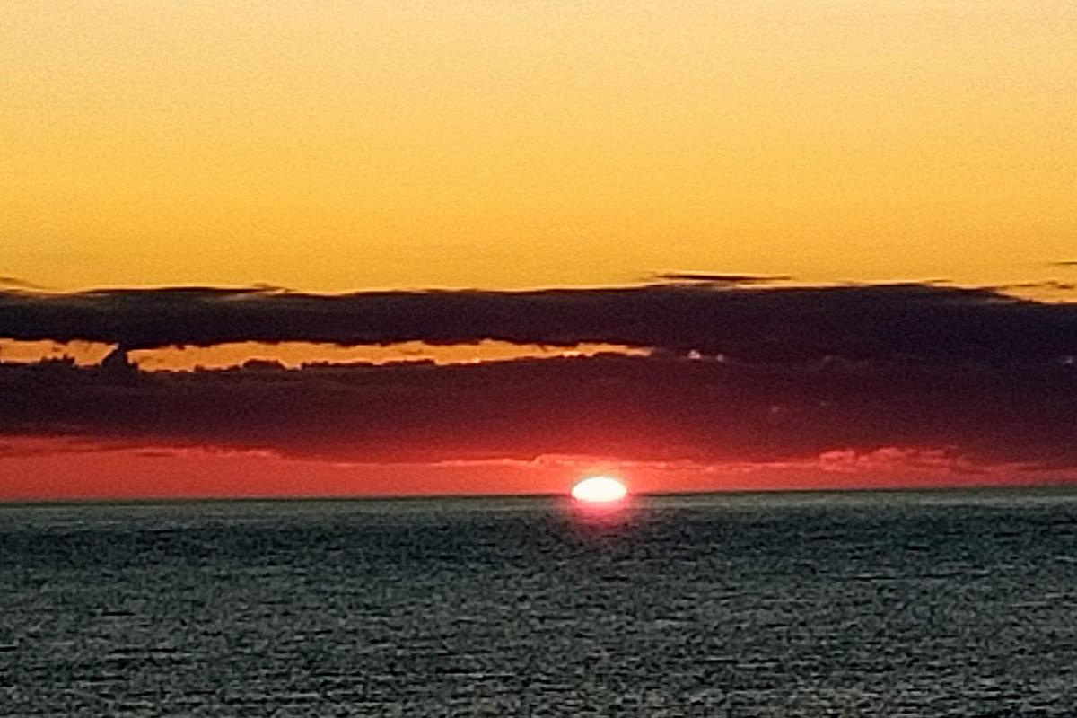
Weather permitting, a beautiful sunset over the Sea of Japan can be seen from the west coast.
Rishiri Island – A mountain towering over the sea
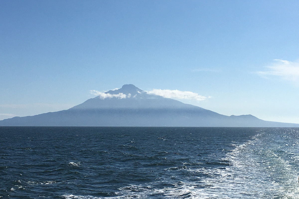
Rishiri Island is about 52 km west of Wakkanai on the Hokkaido mainland. It takes about 2 hours to get there by ferry. Rishiri Island has Rishiri Airport, which offers daily flights from Okadama Airport in Sapporo.
This island’s main spot is Mt. Rishiri, which appears to jut out from the sea and is what is known as “an independent peak on the sea.” In the Ainu language, “Rishiri” means “an island with a high mountain,” and since ancient times its towering beauty has been used as a landmark for navigation and fishing grounds. Because of its high latitude, alpine plants can be seen throughout the island. This island is also free of bears and snakes, so you can enjoy trekking without worrying about dangerous animals.
Rishiri Island is a 60-kilometer round landmass around Mt. Rishiri, which rises 1,721 meters and covers most of the island. Mt. Rishiri is also called Rishiri Fuji meaning Mt. Fuji on Rishiri Island. This mountain was selected as one of the hundred must-climb mountains for mountain lovers. A 1,700 meters mountain is not so high for experienced climbers, however its high latitude, harsh climate, and steep cliffs make this a mountain only suitable for intermediate and advanced climbers. If you are interested in climbing it, make sure you are well equipped and have a plan with enough time to spare.
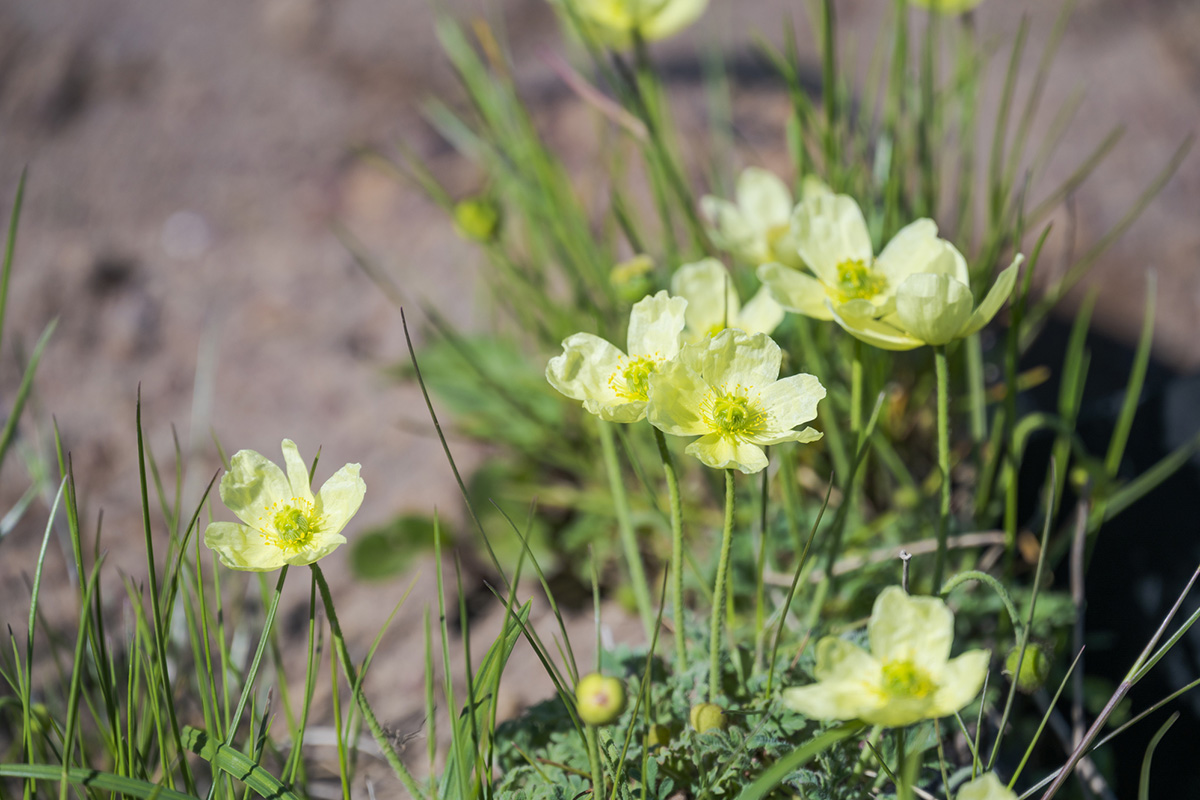
Rishiri Island also has many endemic species that can only be found here. The Rishiri poppy (Rishiri-Hinageshi, Papaver fauriei) is one of them.
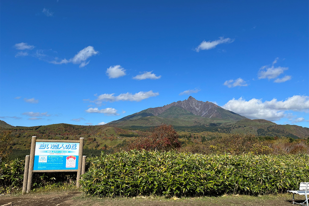
The Hill of Shiroi-Koibito (White Lovers), from where you can see Mt. Rishiri with the same shape as in the picture on the package of Hokkaido’s famous confectionery Shiroi Koibito.
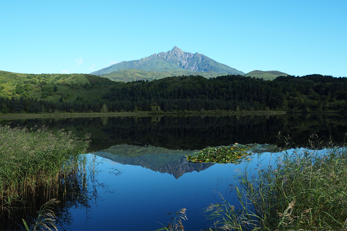
Otatomari Pond, the largest lake on the island. The upside-down image of Mt. Rishiri reflected on the surface of the pond is so beautiful. It has a 1-kilometer walking path where you can enjoy beautiful scenery.
Cape Peshi, located just a few minutes’ walk from Oshidomari ferry port, is a place where you can easily enjoy short trekking. It juts out into the sea. The peak is 93 meters high, though, so when you make it to the top, you will be rewarded with a spectacular view of the island and sea.
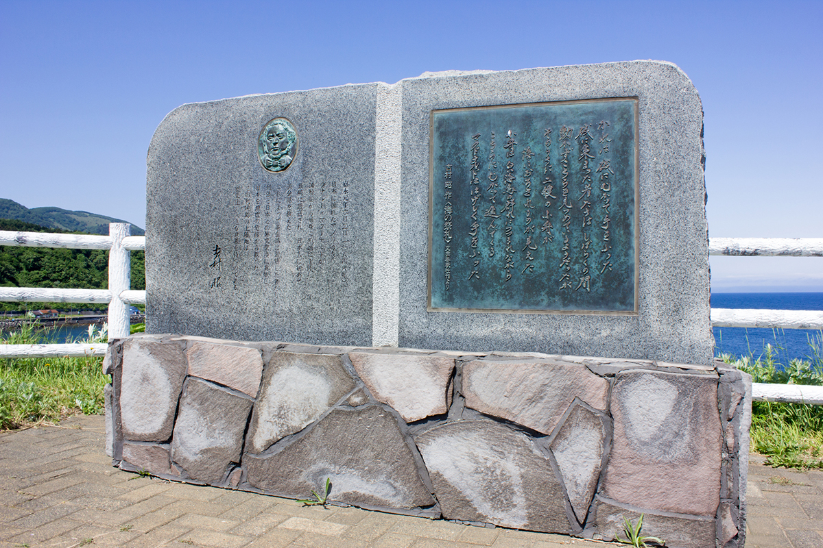
The monument to Ranald McDonald, the first native English teacher in Japan
This is the monument to an American man who landed on this island about 170 years ago. Ranald McDonald, who had a Scottish father and Native American mother, was born in Oregon in 1824. He was fascinated by Japan and, at the age of 24, he came to the waters near Japan on a whaling ship and landed in this place. At the time, Japan had a strict isolation policy for all countries except China and Holland, so he was immediately captured as a smuggler and sent to Nagasaki, Japan’s only window on the rest of the world. During his six-month stay in Japan, he taught English to 14 Japanese, and his students contributed greatly to Japan’s later negotiations with foreign countries in the middle of the 19th century before Japan opened its gates to the world. He is considered to be Japan’s first native English teacher.
Food and Souvenirs
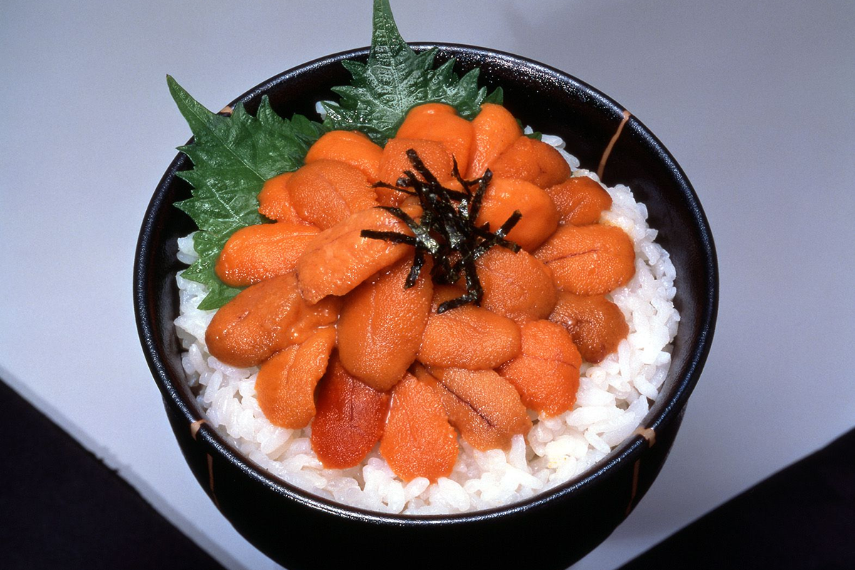
Rishiri and Rebun Islands are first and foremost famous for their delicious sea urchin. You can taste plenty of fresh local sea urchin on both islands.
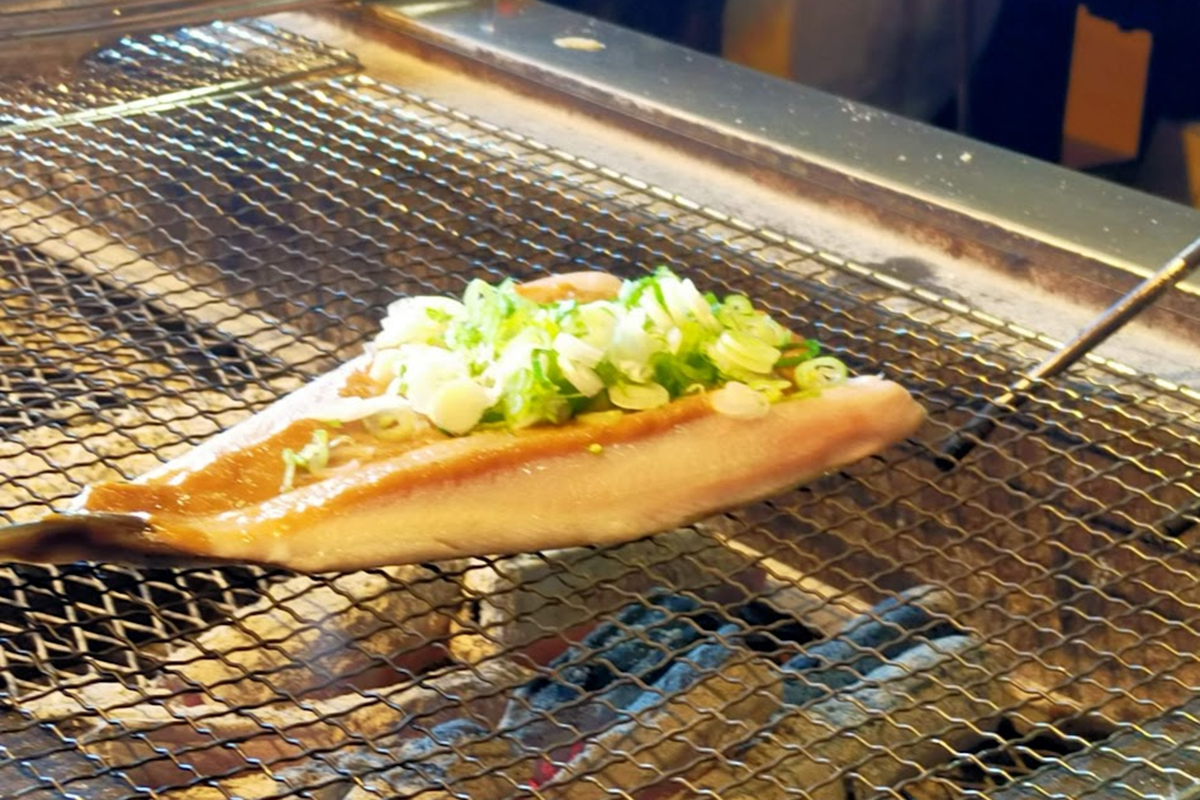
Okhotsk Atka mackerel (hokke) is also a popular seafood here. Grilled seasoned mackerel with sweet miso is the soul food of Rebun Island. You can try them on both islands at an izakaya, a Japanese-style dining pub.
Rishiri kombu (kelp) is the local specialty. Kombu is indispensable for Japanese cooking as it is used to make broth. Rishiri kombu has a reputation for producing good soup stock. Many famous Japanese restaurants in Kyoto use Rishiri kombu for their broth. Dried kombu is light and easy to carry, so it would be a perfect souvenir for Japanese food lovers.
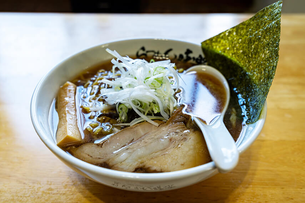
Another popular dish is Rishiri ramen, which uses a lot of Rishiri kombu for the soup stock. There are always long queues in front of the popular ramen restaurant on Rishiri Island. This ramen restaurant, called Miraku, is known as the hardest ramen restaurant to get to in Japan.
North Soya: The northernmost city of Hokkaido and the magnificent views of the Soya Hills
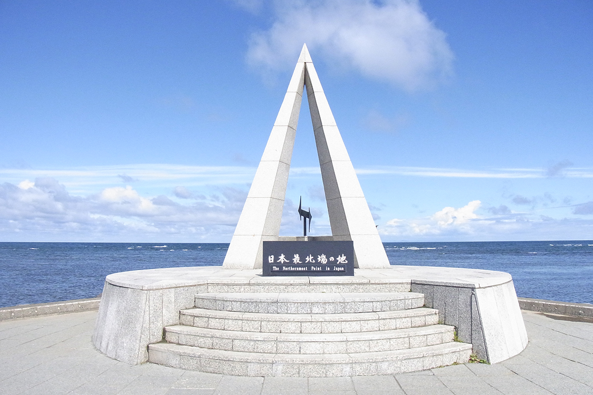
Cape Soya’s Monument of the Northernmost Point of Japan (in Wakkanai)
This monument is located at the tip of Cape Soya, the northernmost cape in Japan. It is located at latitude 45 degrees, 31 minutes, and 22 seconds north. The monument is in the shape of a triangular pyramid, with the letter “N” in the center representing “North” and the circular shape of the base representing peace and harmony.
Since it is the northernmost point of Japan, it often appears as the starting point or goal for those who travel across or around Hokkaido or Japan. On a sunny day, the Russian territory of Sakhalin can be seen just 43 km away.
As it was the gateway to trade with Russia, there used to be active international exchanges, and Russian letters can be found on the signboards in the city.
Wakkanai is a two-hour flight from Tokyo or a five-hour drive from Sapporo via the expressway.
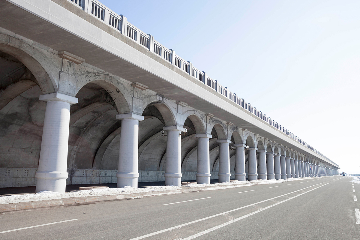
The Northern Breakwater Dome
This breakwater dome was built in 1936. Its half-arched roof and the 70 thick columns are reminiscent of ancient Roman architecture, and it has been designated as a Hokkaido Heritage site as a historical structure.
The structure has close connections with the history of Japan and Russia: from the end of the Russo-Japanese War in 1905 until after World War II, the southern half of Sakhalin used to be Japanese territory and was called Karafuto. At that time, a shipping route to Sakhalin was opened at Wakkanai Port, and the port was so busy with people and cargo. However, strong winds blew throughout the year in Wakkanai Port; sometimes people were swept away by high waves and winds, and fell into the sea. This dome was built to protect people from the wind. Its height is 14 m and its length is 427 m.
At the end of World War II in 1945, the shipping route to Sakhalin was discontinued, and the dome’s role also came to an end. However, after three years of restoration in 1980, it still works as a breakwater. Nowadays, thanks to its unique form, various events are held using this dome as a stage, and it is also used as a filming location for movies and commercials.
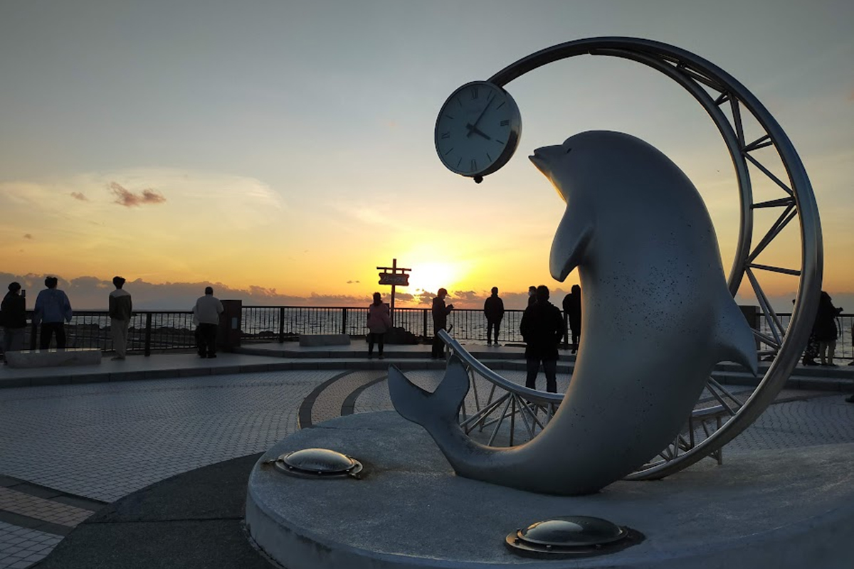
Cape Noshappu
A cape located on the west of Cape Soya and facing Mt. Rishiri is famous for its beautiful sunsets over the Sea of Japan. Visitors flock to the cape just before sunset. A famous dolphin monument at the cape will make a lovely picture.
The Soya Hills with their magnificent views
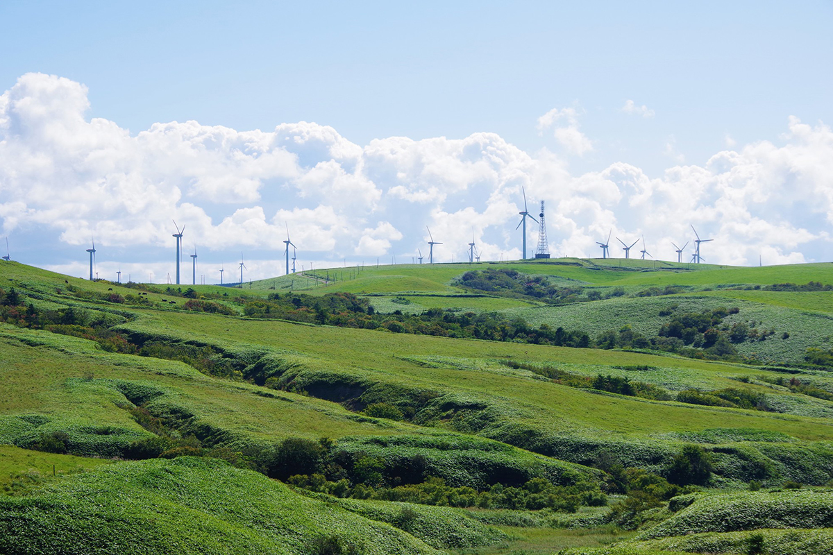
Spreading out to the south of Cape Soya are the Soya Hills, the northernmost hilly area in Japan. The characteristic scenery of rolling green hills was formed during the Ice Age. It was created by the slow movement of soil caused by the repeated freezing and thawing of the ground around 10,000 years ago. This is called periglacial landform. These landscapes used to be found in many places in Hokkaido, however, most of them were lost due to the development of Hokkaido from the late 19th to 20th century. The Soya Hills are a precious remnant that still remains in this landscape. Originally the hills were covered by dense forests, but trees on the hills were burned by fires around the late 19th century, revealing their beautiful appearance. Now, windmills for power generation dot the wide-open hillsides, and grazing cattle can be seen. The hills are home to one of Japan’s largest wind farms, which takes advantage of the strong winds always blowing in this area. 57 wind turbines have a total output of 57,000 kilowatts, which is the largest in Japan.
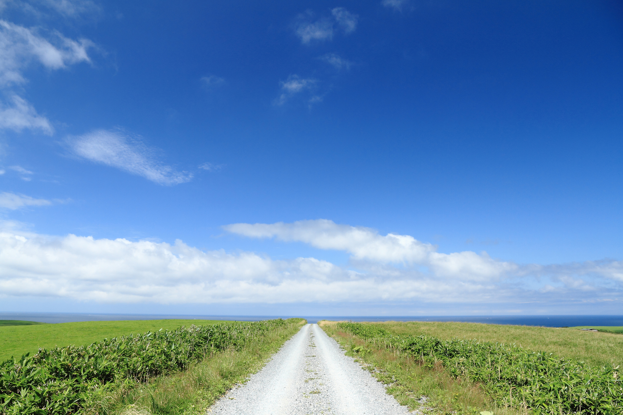
The White Path
The White Path, paved with scallop shells in the middle of the Soya Hills, is a popular photo spot on social networking sites. In fact, this white path is made of scallop waste. Wakkanai has a thriving fisheries industry, and scallops in particular are widely loved not only by local residents but also by tourists from Japan and abroad as the city’s typical seafood. However, scallop shells have long been thrown away as waste because they have no use. After a long process of trial and error, The White Path was set up in 2011, hoping to somehow recycle scallop waste from the standpoint of environmental conservation. Crushing shells into small pieces and laying them on the path creates a beautiful landscape that matches the blue sky and sea.
Wakkanai has four of Japan’s northernmost footpaths. The short course starts with The White Path, and its breathtaking scenery always attracts visitors from many countries.
The path is closed during November to late May because this region is covered with deep snow during winter. Be sure to check before you visit.
The northernmost region in Hokkaido is a place that is difficult to reach even from Sapporo, the capital city of Hokkaido. However, it is also home to rich and unspoiled nature, with many amazing landscapes and plants that can only be seen here. If you want to feel the grandeur of nature, why not come to northernmost Hokkaido? It’s really worth a visit.
—
Rishiri, Rebun und Nord-Soya: Unberührte Natur im Norden Hokkaidos
Hokkaido, Japans nördlichste Insel, beherbergt im äußersten Norden die Inseln Rishiri und Rebun sowie das Gebiet Nord-Soya. Diese Region, Teil des Rishiri-Rebun-Sarobetsu-Nationalparks, bietet spektakuläre Landschaften und seltene Alpenpflanzen, die Naturliebhaber begeistern. Dieser Blogbeitrag stellt die Highlights vor und gibt Inspiration für Ihre Reise.
Rebun: Die schwimmende Blumeninsel
Rebun, zwei Stunden per Fähre von Wakkanai entfernt, wird als „schwimmende Blumeninsel“ gefeiert. Von Juni bis August blühen hier seltene Pflanzen wie die Rebun-Atsumori-so (eine endemische Orchidee) und die Rebun-Usuyuki-so (Edelweiß), die nur auf dieser Insel vorkommen. Die Orchidee, ein Naturdenkmal Hokkaidos, ist stark gefährdet und durch Zäune geschützt. Im Alpengarten im Norden der Insel können Besucher sie bis August bewundern.
Rebun ist ideal zum Wandern: Der Momoiwa-Aussichtskurs (7 km, 2–3 Stunden) bietet Blicke auf den „Pfirsichfelsen“ und den Mount Rishiri. Der Kap-Rundkurs (12 km, 4–5 Stunden) führt zu majestätischen Ausblicken, etwa am Kap Sukoton, dem nördlichsten Punkt. Die anspruchsvolle Acht-Stunden-Route (16 km) entlang der Westküste ist für erfahrene Wanderer geeignet. Da es keine Bären oder Schlangen gibt, ist Wandern hier besonders entspannt. Bitte respektieren Sie die empfindliche Flora – das Pflücken ist verboten.
Rishiri: Der Berg im Meer
Rishiri, ebenfalls zwei Stunden per Fähre von Wakkanai erreichbar, wird vom Mount Rishiri (1.721 m) dominiert, auch „Rishiri Fuji“ genannt. Dieser Berg, einer der „100 Berge Japans“, ist nur für geübte Wanderer geeignet, da sein raues Klima und steile Klippen Herausforderungen bieten. Die Insel beherbergt endemische Pflanzen wie die Rishiri-Hinageshi (Mohn). Einfachere Ausflüge führen zum Otatomari-See mit seinem spiegelnden Bergblick oder zum Kap Peshi (93 m) für kurze Wanderungen.
Nord-Soya: Der nördlichste Punkt Japans
Nord-Soya umfasst Wakkanai, die nördlichste Stadt Hokkaidos. Am Kap Soya, Japans nördlichstem Punkt, steht ein Denkmal, und bei klarem Wetter ist Sachalin (43 km entfernt) sichtbar. Die Soya-Hügel, geformt in der Eiszeit, bieten sanfte grüne Landschaften mit Windmühlen, die Japans größten Windpark bilden. Der „Weiße Pfad“, gepflastert mit Muschelschalen, ist ein beliebter Fotospot. Vier der nördlichsten Wanderwege Japans starten hier, sind aber von November bis Mai wegen Schnee geschlossen.
Das Nord-Breakwater-Dome in Wakkanai, ein historischer Wellenbrecher von 1936, erinnert an die Handelsroute nach Sachalin. Am Kap Noshappu locken spektakuläre Sonnenuntergänge über dem Japanischen Meer.
Fazit: Ihr Abenteuer im Norden Hokkaidos
Rishiri, Rebun und Nord-Soya bieten unberührte Natur, die schwer zu erreichen, aber unvergesslich ist. Von seltenen Alpenpflanzen auf Rebun bis zu den weiten Hügeln von Soya – diese Region ist ein Muss für Naturliebhaber. Bei Hokkaido Treasure Island Travel gestalten wir nachhaltige Reisen, die die lokale Natur und Kultur respektieren. Besuchen Sie unsere Website (https://hokkaido-treasure.com/) für Reiseideen und kontaktieren Sie uns für Ihre Traumreise!